- 7000 Plus Meter PeaksPosted 2 years ago
- Deosai Plateau TourPosted 2 years ago
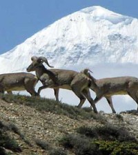
Diamir Valley
Around Nanga Parbat Mazeno Pass Trek
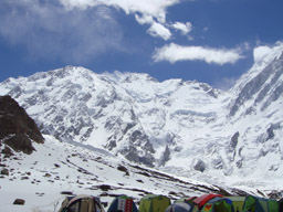
Nanga Parbat, Sanskrit for “Naked Mountain” is so named because some of its slopes are so steep that they are bereft of vegetation and snow. According to the local old legend, Nanga Parbat is also called Diamir, which means abode of fairies.
It is believed that the Queen of fairies lives there in a castle made of solid crystal-clear ice, which is guarded by gigantic snow serpents and frogs. The earlier disasters in climbing this mountain are attributed to the displeasure of fairies. Nanga Parbat is not a single peak but consists of 20km long series of peaks and ridges culminating in an ice crest of (8125m).
Its South Face known as Rupal Face is (5000m) high, while the North or Raikot Face plunging over (7000m) from the summit to the Indus forms one of the world’s deepest gorge. This expedition takes us to the South side, which is known as Rupal Face.
Fairy Meadows Trek
Many people have called Fairy Meadows the most beautiful place in Pakistan. These lush, green meadows and forests lie at the base of Nanga Parbat, the ninth highest mountain in the world. Fairy Meadows is a very peaceful and relaxing place to enjoy the mountain atmosphere and hospitality of the local people. From Fairy Meadows you can enjoy nice day walks or you can trek to Nanga Parbat Base Camp for an overnight experience. For mountaineers, there are several peaks waiting to be climbed.
More serious trekkers can also trek over a series of passes from Fairy Meadows to begin circling Nanga Parbat, the killer mountain. Fairy Meadows is very accessible from Gilgit- you could even visit in a long day, but it is always better to spend as much time as possible in a place like this.
The jeep road that climbs out of the Indus Valley to Fairy Meadows is quite exciting, but an easier way to reach the meadows than walking up the dusty road. Nice hotels and bungalows are available at the meadows, but you may also choose to camp in the grassy sites.
Nanga Parbat Rupal Face Trek & Hunza Tour
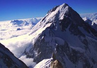
Nanga Parbat has tremendous vertical relief over local terrain in all directions. To the south, Nanga Parbat boasts what is often referred to as the highest mountain face in the world: the Rupal Face rises 4,600 m (15,000 feet) above its base. To the north, the complex, somewhat more gently sloped Rakhiot Flank rises 7,000 m (22,966 feet) from the Indus River valley to the summit in just 27 km, one of the 10 greatest elevation gains in so short a distance on Earth.
Nanga Parbat Diamir BC Trek
Nanga Parbat is the second highest mountain of Pakistan and ninth highest in the world. It in not part of the Karakoram. It is separated from the Karakoram by the mighty Indus River. Since the first disastrous British expedition led by A. F. Mummery in 1895 A.D.
mountaineers have tried to ascent its summit through different routes but few lucky ones have succeeded. In 1934 four German climbers and 6 porters perished in a storm. In 1937 disaster 18 Sherpas and 12 climbers were buried alive by avalanche that covered their camp. In fact Nanga Parbat has claimed more lives than any other 8000ers relative to the number of attempts, hence it is named as the frightening nickname of Killer Mountain.
It was first climbed in 1953 A.D. by a joint Austrian – German Expedition. Hermann Buhl made the final ascent in a hard 41 hours solo ordeal without oxygen. Italian mountaineer Reinhold Messner climbed the south face (Rupal Face) with his brother Gunther in 1970, descending by the Diamir face, where Gunther lost his life in an adventure.
Related Posts

You must be logged in to post a comment Login